
Interagency Partnerships and Documenting Barksdale’s Ford
Three state government agencies work together to document and plan the preservation of a river crossing dating to the 18th century in Henry County.
By Dr. John Henshaw | DHR Archaeologist for the Western Region
Recently, Hayden Bassett of the Virginia Museum of Natural History (VMNH) invited DHR staff to an interagency discussion with VMNH and the Virginia Department of Transportation (VDOT) regarding a surprising find along the banks of the Smith River in Henry County. Buried in the riverbank and now uncovered by drainage from a nearby culvert is a section of a log corduroy road that was a part of a ford for the river.
This ford had a particularly interesting history for the county and the broader region. As early as 1753, the ford is mentioned as part of the North-South corridor of the Great Road. Around the same time, the Fry-Jefferson map of Virginia depicts the Great Road crossing the Smith River (then also called the Irvine River) in this area downriver from Blackberry Creek. In the 1770s, the surrounding land was owned by Henry Barksdale. In 1776-1777, Barksdale appears on the list of names in the county pledging allegiance to the newly independent country and the Commonwealth of Virginia. When Henry County split from Pittsylvania County in 1777, the county wanted to place the new county’s courthouse and jail in a more central location. They picked the area of Stanleytown along the Smith River. Henry Barksdale gave some of his land on the northeast side of the river to the court for this purpose. The now rediscovered ford then became important for access to official activities of the county and the court until the courthouse was moved several miles away to Martinsville in 1792. This ford would remain in common usage at least throughout the 19th century as a key spot to cross the river for travelers and cattle drivers. The name Barksdale’s Ford was retained in some form throughout this time. This ford likely witnessed at least sporadic usage as late as the early 20th century, when the advent of the automobile necessitated stronger bridges. A single span bridge with concrete piers was constructed immediately downriver from Barksdale’s Ford, which likely saw the ford fall out of use and into disrepair as automobiles slowly became more widespread. A pier from the early bridge was located at the same time the ford was rediscovered, but that bridge was later replaced by a stronger bridge more suited for increased automobile traffic, so only the bases for the original piers remain.
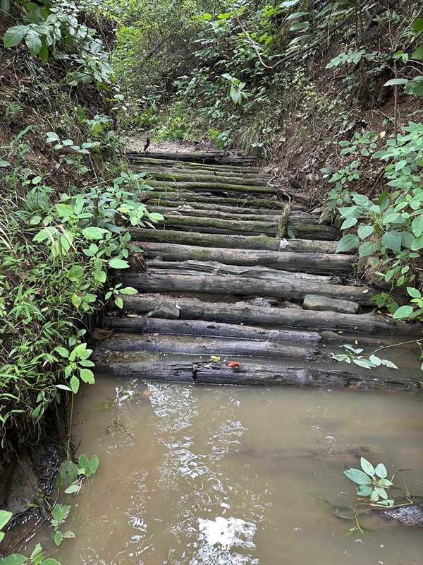
The discovery of the partially submerged Barksdale’s Ford initiated rapid coordination between VMNH, VDHR, and VDOT to determine the best path forward for documenting and preserving this site that served an important role in the history of Henry County and in the connectivity of the early colonies. The urgency was driven by the imminent resumption of activity by the Philpott Dam that would cause the site to be inundated by multiple feet of water. It was necessary to document or salvage the site quickly before the increasing water level either damaged what remained or made the site inaccessible during normal dam activity.
A site visit was led by Hayden Bassett and joined by representatives from VDHR and VDOT to create a plan for documentation, to determine whether salvage was necessary, and to identify any possibility for additional protection of the site. This discussion resulted in a plan for DHR Western Region Archaeologist, John Henshaw, and DHR State Underwater Archaeologist, Brendan Burke, to join VMNH’s Hayden Bassett on a second site visit to photograph and map the exposed ford. A photogrammetry model was then generated to document the logs in their present condition, before it would become flooded with water in the near future. The photogrammetry model was tied into several GPS control points to precisely place the image in space in case any data is lost from river activity following the resumption of power generation by the dam. A plan was also put into place for future coordination between DHR, VMNH, and VDOT to assess site conditions and plan for protection of the site in the event of future VDOT activity at the site.
Barksdale’s Ford created a welcome opportunity for multiple state agencies to partner together to plan for the long-term protection of a significant archaeological site. This project demonstrated the importance of interagency cooperation and the ability of state partners to rapidly respond to historic preservation needs in the Commonwealth.
Legal Disclaimer:
EIN Presswire provides this news content "as is" without warranty of any kind. We do not accept any responsibility or liability for the accuracy, content, images, videos, licenses, completeness, legality, or reliability of the information contained in this article. If you have any complaints or copyright issues related to this article, kindly contact the author above.
